Open Windows At Night: "Dramatic Pattern Change" For US East Temps Ahead
The NWS Weather Prediction Center is forecasting a dramatic temperature shift across the eastern two-thirds of the U.S., from blistering heat to a cool-down by the end of the week. That's welcome news for residents in the Mid-Atlantic and Northeast, where relentless heat has sent HVAC usage higher and power bills through the roof.
A dramatic pattern change is on the way as much of the eastern two-thirds of the country goes from sizzling temperatures to cooler & more comfortable conditions by the end of the week. While much of the Heartland & Northeast cool down, the heat persists in Florida & the Southwest pic.twitter.com/nKO6BwXLoG
— NWS Weather Prediction Center (@NWSWPC) July 29, 2025
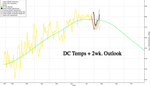
A two-week temperature forecast for the Washington, DC metro area shows readings likely sliding below the 30-year average by week's end and staying there for 10-12 days. With peak summer already locked in on July 15 for the Northern Hemisphere, it's all downhill from here.
Northeast meteorologist Mark Margavage expects the following for the next two weeks:
Heavy Rain Thursday Afternoon(interior) -Friday Morning(Coast)
Below Average Temperatures move in promptly on July 31
Temperatures Rebound towards normal August 4-8
A Brief Surge of Above Normal Temperatures August 9 ahead of another Cold Front
Severe Weather Possible August 9 with Cold Front Passage
Below Normal Temperatures return August 10 - TBD ~Meteorologist Mark Margavage
Looking out through the first 10-12 days of August in the Northeast US, here is what I see:
— Mark Margavage (@MeteoMark) July 29, 2025
🟢Heavy Rain Thursday Afternoon(interior) -Friday Morning(Coast)
🔵Below Average Temperatures move in promptly on July 31st
⬆️Temperatures Rebound towards normal August 4-8
🔴A Brief Surge… pic.twitter.com/pA2HcvDJev
A separate forecast by WeatherBELL Chief Forecaster Joe Bastardi predicts an inflection point in the Atlantic hurricane season, shifting from calm to more active conditions in early August.
Still holding with this forecast ( first was made July 24). MJO on the move so CPAC and EPAC coming to life, Atlantic will next week, Notice how all Pacific development has been in normal to below SST meaning that is not everything, but means MJO certainly is something… https://t.co/BUnrazW0qj pic.twitter.com/dDkaBraSSX
— The American Storm (@BigJoeBastardi) July 29, 2025
Here are more details about the power bill crisis unfolding across the Mid-Atlantic and Northeast states, regions largely governed by radical leftists that have mismanaged the power grid amid an influx of AI data center demand.
Turn off those HVAC units and open the doors at night to trim power costs.
Loading recommendations...
